


Homepage
•
Learning Library
•
Blog
•
Community PBL lessons allow students to make a difference
Expand breadcrumbs
- Learning Library
- Blog
- Community PBL lessons allow students to make a difference
- Homepage
- •
- Learning Library
- •
- Blog
- •
- Community PBL lessons allow students to make a difference
Community PBL lessons allow students to make a difference
Did you know that in the time of John Smith, oysters were as big as dinner plates, and the massive reefs were hazardous to maritime navigation? Over time, their population drastically dwindled, and as a result, the overall health of the Chesapeake Bay watershed has as well.
This is the problem we posed to our fourth grade students to give them an authentic learning opportunity. You see, the Chesapeake Bay watershed just happens to be in our own backyard, and what better way to target objectives than to get students involved in a real-world problem that impacts their community?
One newer and innovative strategy for restoring the oyster population is through the construction of modified, artificial oyster reefs. These are often referred to as “oyster castles” and are built from interlocking blocks made of a concrete and recycled oyster shell mixture.
Since our students study land and aquatic ecosystems, including the impact of human interactions within these systems, oyster castles are an engaging and natural way to help students learn more about the targeted objectives. Our students used their skills as marine scientists and geographers to analyze data to determine the best location to expand oyster castles in their local watershed.
Hook students with a Skype field trip
We were able to arrange a Skype session with Oyster Reef Keepers of Virginia, a local conservation group on the banks of the Lynnhaven River. Executive director Laurie Sorabella gave our students a close-up look at oyster castles in various stages of development. Connecting our students to experts like Sorabella nicely addresses the Global Collaborator standard within the ISTE Standards for Students, which instructs students to use collaborative technologies to work with others, including peers, experts or community members, to examine issues and problems from multiple viewpoints.
We used a need-to-know board to frame our work. We posted large sheets of bulletin board paper around the room with these headings: What do we know? What do we need to know? How will we find out? What is our problem? Right after the Skype session, students discussed what they heard and added to the sections of the chart. They looked at all of their questions and discussed which ones to start with. Each day, we went back to the posters to add new information, create new questions, add sources and analyze problems we encountered. This was an organic process that proved to be a vital tool in keeping the work focused, forward moving and student centered. You can add technology to this process by recording information using collaborative tools like Flipgrid or Google Docs.
Keep the objectives at the forefront
This unit was crafted as an interdisciplinary unit focused on science and math as well as reading and writing. While students researched, teachers taught mini-lessons on specific skills, such as finding reliable sources, skimming text, paraphrasing information and keeping track of sources. This portion of the project supported the Knowledge Constructor standard of the ISTE Student Standards. Since the performance task was purposefully crafted as an expository writing piece, which was an objective for our students, teachers focused their writing instruction on laying a solid foundation in the structure and components of this writing genre.
Show students how to look for patterns and trends
A key component of an authentic project-based learning task is data analysis. Oyster Reef Keepers of Virginia provided our students with historical raw data, such as oyster growth and number of spat (baby oysters) from various locations within the Lynnhaven River watershed. We also included salinity measurements. In small groups, students examined the data looking for patterns and trends. They looked for locations where oysters were growing and compared the numbers of spat. Using the data, students sought locations conducive to oyster growth and development.
Use ARCGIS to map data
After looking at the data on spreadsheets, we needed a visual representation that would help draw all of the data points together. We also wanted an electronic tool that would allow us to create a map and let students cooperatively create the final product. We found the answer in ArcGIS Online, a web-based mapping and data-analysis tool that allows students to collaborate, create and share interactive maps and apps across a variety of devices.
Tom McCaffrey, GIS coordinator, University of Calgary, summarizes it best: "Using GIS as a decision-making tool is a smart way of gathering all the things you already know and placing them in a single spot so you can see the entire picture."
That is exactly what we were able to do! Our students collaboratively plotted the amount of oyster growth, number of spat and salinity data on a map of the Lynnhaven River watershed.
The map gave students a snapshot of all of their data to inform the location for their oyster castle. This data analysis component is another way to support ISTE's Computational Thinking standard (Students collect data or identify relevant data sets, use digital tools to analyse them, and represent data in various ways to facilitate problem-solving and decision-making.)
Here is a helpful guide for getting started with ARCGIS. The ESRI education website offers steps for creating a free online account for your school.
Teach them how to synthesize information and make their case
Researching, examining data, creating maps and analyzing those maps equipped students with the information necessary to make a decision for the oyster castle location. The performance task required them to synthesize their findings into a two-paragraph essay, like this one by Quinn.
The first paragraph gave background information on castles and their importance, and the second proposed a carefully selected location in the Lynnhaven River along with supporting evidence. Students included details using specific language of the discipline that revealed application of their content knowledge. This is another point in the project where we could assess student performance on targeted learning objectives, such as the Common Core standards for producing clear and coherent writing and conducting short research projects that build knowledge through investigation of different aspects of a topic.
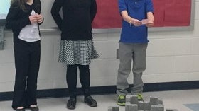
After reading their essays, we placed students in groups according to their chosen locations. Then they gave presentations outlining their strongest supporting evidence to a panel of experts and community members interested in expanding the placement of new oyster castles. In addition, they designed models of their castles in TinkerCAD, a free online computer-aided drafting program, and then used the 3D printer to create them. Students were very excited to see their designs come to life.
The power of this authentic task came alive as students presented their findings to community members and fielded multiple questions on the spot. They used their content knowledge as evidence to support their decisions about the best locations for new castles as well as castle design.
Students meet standards and learn valuable skills
This project far exceeded our expectations. Students not only designed castles and presented them to a panel, but the printed copies of their designs are now used by members of Oyster Reef Keepers of Virginia as they present castle possibilities to prospective castle owners.
Students decided they wanted to sponsor an oyster castle and ran a fundraiser to sell the 3D printed products they designed. Their knowledge of ArcGIS provided a foundation that led to the creation of ArcGIS Story Maps in a subsequent unit. This unit had a lot of bang for the buck, as it gave students an enjoyable opportunity to develop their communication, collaboration, design and analytical skills, which are all integral to the ISTE Standards for Students, the Common Core English Language Arts Standards and our local learning objectives.
Yes, you can try this at your school!
What's going on in your community? Look for ways you can use problems in your own backyard as a platform and jumping-off point for authentic learning opportunities. Discuss with local experts, and innovate and empower students to take action, all while teaching grade-level objectives.
Incorporate supportive technologies that are not used for technology’s sake, but because they allow students to develop deeper meaning, become engaged and invested, and get an authentic look at work in the field. Never underestimate the impact your students can have on the world.
Melissa Follin is a third grade teacher in Virginia Beach City Public Schools. She has previously taught first and fourth grades and was a gifted resource teacher for five years. She was named 2019 Citywide Teacher of the Year. She focuses on authentic learning experiences for her students that include appropriate technologies and build an understanding of sustainability.
Christina Troxell is an instructional technology specialist at Kemps Landing/Old Donation School in Virginia Beach, Virginia. She collaborates with classroom teachers on the effective integration of technology. She strives to create a supportive learning environment for teachers and students.
This is an updated version of a post that originally published on July 31, 2015.